
Thank you for supporting this site ❤️
Make a donation
Make a donation
Peuterey topographic map
Click on the map to display elevation.
Thank you for supporting this site ❤️
Make a donation
Make a donation
About this map
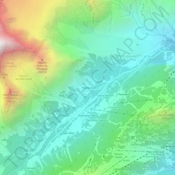
Name: Peuterey topographic map, elevation, terrain.
Location: Peuterey, Courmayeur, Valle d'Aosta, 11013, Italia (45.78528 6.90305 45.82528 6.94305)
Average elevation: 1,934 m
Minimum elevation: 1,330 m
Maximum elevation: 3,515 m
Thank you for supporting this site ❤️
Make a donation
Make a donation
Other topographic maps
Click on a map to view its topography, its elevation and its terrain.