
Welwyn Garden City topographic map
Interactive map
Click on the map to display elevation.
About this map
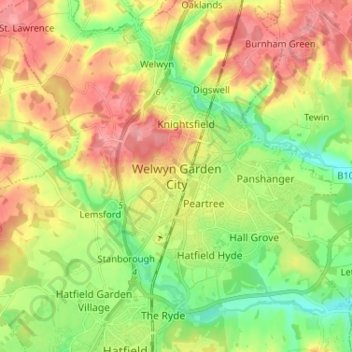
Name: Welwyn Garden City topographic map, elevation, terrain.
Average elevation: 89 m
Minimum elevation: 48 m
Maximum elevation: 134 m
Other topographic maps
Click on a map to view its topography, its elevation and its terrain.
Welwyn
Reino Unido > Inglaterra > Hertfordshire > Welwyn Hatfield
Welwyn, Digswell, Welwyn Hatfield, Hertfordshire, Inglaterra, Reino Unido
Average elevation: 101 m
Hatfield
Reino Unido > Inglaterra > Hertfordshire > Welwyn Hatfield
Hatfield, Welwyn Hatfield, Hertfordshire, Inglaterra, Reino Unido
Average elevation: 90 m