
Thank you for supporting this site ❤️
Make a donation
Make a donation
Colony Park topographic map
Click on the map to display elevation.
Thank you for supporting this site ❤️
Make a donation
Make a donation
About this map
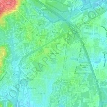
Name: Colony Park topographic map, elevation, terrain.
Average elevation: 94 m
Minimum elevation: 72 m
Maximum elevation: 159 m
Thank you for supporting this site ❤️
Make a donation
Make a donation
Other topographic maps
Click on a map to view its topography, its elevation and its terrain.
Mason Farm Biological Reserve
United States > North Carolina > Orange County > Chapel Hill
Average elevation: 87 m