
Thank you for supporting this site ❤️
Make a donation
Make a donation
Reno topographic map
Click on the map to display elevation.
Thank you for supporting this site ❤️
Make a donation
Make a donation
Reno
Reno is just east of the Sierra Nevada, on the western edge of the Great Basin at an elevation of about 4,400 feet (1,300 m) above sea level. Numerous faults exist throughout the region. Most of these are normal (vertical motion) faults associated with the uplift of the various mountain ranges, including the Sierra Nevada.
Thank you for supporting this site ❤️
Make a donation
Make a donation
About this map
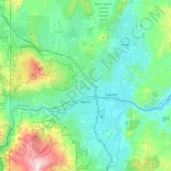
Name: Reno topographic map, elevation, terrain.
Location: Reno, Washoe County, Nevada, United States (39.39243 -120.00233 39.72344 -119.69935)
Average elevation: 1,650 m
Minimum elevation: 1,316 m
Maximum elevation: 3,010 m
Thank you for supporting this site ❤️
Make a donation
Make a donation