
Thank you for supporting this site ❤️
Make a donation
Make a donation
Saint Augustine topographic map
Click on the map to display elevation.
Thank you for supporting this site ❤️
Make a donation
Make a donation
About this map
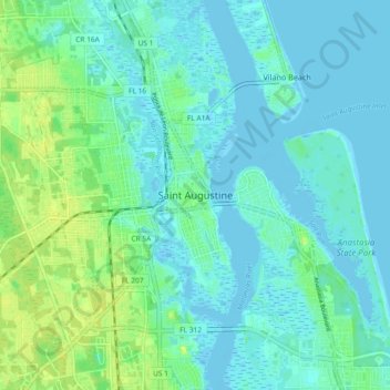
Name: Saint Augustine topographic map, elevation, terrain.
Average elevation: 5 m
Minimum elevation: -5 m
Maximum elevation: 21 m
Thank you for supporting this site ❤️
Make a donation
Make a donation
Other topographic maps
Click on a map to view its topography, its elevation and its terrain.
Castillo de San Marcos
United States > Florida > Saint Johns County > Saint Augustine
Average elevation: 2 m
Julington Creek Plantation Park
United States > Florida > Saint Johns County > Fruit Cove
Average elevation: 7 m
Twelve Mile Swamp Conservation Area
United States > Florida > Saint Johns County
Average elevation: 8 m
Thank you for supporting this site ❤️
Make a donation
Make a donation