
Belluno topographic map
Click on the map to display elevation.
Belluno
The national park includes mountain ranges of Alpi Feltrine (Vette di Feltre, Cimonega, Pizzocco, Brendol, Agnelezze), Monti del Sole, Schiara, Talvena, Prampèr, and Spiz di Mezzodì. There are high-altitude areas, karst rocks, and debris slopes, ideal habitat for high-mountain species.
About this map
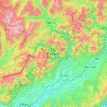
Name: Belluno topographic map, elevation, terrain.
Location: Belluno, Veneto, Italy, Parco Nazionale Dolomiti Bellunesi (46.04338 11.76610 46.31945 12.26498)
Average elevation: 1,121 m
Minimum elevation: 158 m
Maximum elevation: 3,181 m
Other topographic maps
Click on a map to view its topography, its elevation and its terrain.
Pieve di Cadore
Italy > Veneto > Belluno > Pieve di Cadore > Pieve di Cadore
Average elevation: 1,116 m
Gruppo del Pomagagnon
Italy > Veneto > Belluno > Cortina d'Ampezzo
Pomagagnon is a mountain of the Dolomites in Belluno, northern Italy. It has an elevation of 2,450 metres (8,038 ft) and is the southernmost mountain of the Cristallo Group, towering 1,200 metres (3,937 ft) over the resort of Cortina d'Ampezzo. The mountain is part of the "Natural Park of the Ampezzo…
Average elevation: 1,758 m