
Ottawa County topographic map
Interactive map
Click on the map to display elevation.
About this map
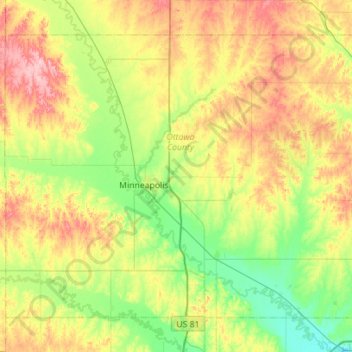
Name: Ottawa County topographic map, elevation, terrain.
Location: Ottawa County, Kansas, USA (38.95830 -97.93012 39.30734 -97.37003)
Average elevation: 410 m
Minimum elevation: 356 m
Maximum elevation: 502 m
Other topographic maps
Click on a map to view its topography, its elevation and its terrain.
Independence
USA > Kansas > Independence
Independence, Montgomery County, Kansas, 67301, USA
Average elevation: 245 m