
Make a donation
Chiapas topographic map
Click on the map to display elevation.
Make a donation
Chiapas
The Sierra Madre de Chiapas runs parallel to the Pacific coastline of the state, northwest to southeast as a continuation of the Sierra Madre del Sur. This area has the highest altitudes in Chiapas including the Tacaná Volcano, which rises 4,093 m (13,428 ft) above sea level. Most of these mountains are volcanic in origin although the nucleus is metamorphic rock. It has a wide range of climates but little arable land. It is mostly covered in middle altitude rainforest, high altitude rainforest, and forests of oaks and pines. The mountains partially block rain clouds from the Pacific, a process known as Orographic lift, which creates a particularly rich coastal region called the Soconusco. The main commercial center of the sierra is the town of Motozintla, also near the Guatemalan border.
Make a donation
About this map
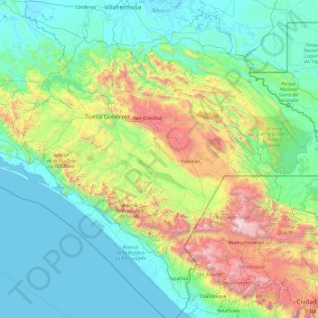
Name: Chiapas topographic map, elevation, terrain.
Location: Chiapas, Mexico (14.53107 -94.13916 17.98529 -90.37151)
Average elevation: 645 m
Minimum elevation: -3 m
Maximum elevation: 4,131 m
Make a donation
Other topographic maps
Click on a map to view its topography, its elevation and its terrain.