
Avril topographic map
Interactive map
Click on the map to display elevation.
About this map
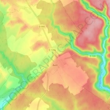
Name: Avril topographic map, elevation, terrain.
Average elevation: 285 m
Minimum elevation: 199 m
Maximum elevation: 346 m
Other topographic maps
Click on a map to view its topography, its elevation and its terrain.
Lunéville
France > Grand Est > Meurthe-et-Moselle
Lunéville, Meurthe-et-Moselle, Grand Est, France métropolitaine, 54300, France
Average elevation: 249 m
Longwy
France > Grand Est > Meurthe-et-Moselle
Longwy, Val-de-Briey, Meurthe-et-Moselle, Grand Est, France métropolitaine, 54400, France
Average elevation: 332 m
La Chapelle Saint-Roch
France > Grand Est > Meurthe-et-Moselle > Labry
La Chapelle Saint-Roch, Labry, Val-de-Briey, Meurthe-et-Moselle, Grand Est, France métropolitaine, 54800, France
Average elevation: 204 m
Varangéville
France > Grand Est > Meurthe-et-Moselle
Varangéville, Nancy, Meurthe-et-Moselle, Grand Est, France métropolitaine, 54110, France
Average elevation: 240 m
Villers-la-Chèvre
France > Grand Est > Meurthe-et-Moselle
Villers-la-Chèvre, Val-de-Briey, Meurthe-et-Moselle, Grand Est, France métropolitaine, 54870, France
Average elevation: 352 m
Le Pâtis de Mandville
France > Grand Est > Meurthe-et-Moselle > Épiez-sur-Chiers
Le Pâtis de Mandville, Épiez-sur-Chiers, Val-de-Briey, Meurthe-et-Moselle, Grand Est, France métropolitaine, 54260, France
Average elevation: 257 m
Courcelles
France > Grand Est > Meurthe-et-Moselle
Courcelles, Toul, Meurthe-et-Moselle, Grand Est, France métropolitaine, 54930, France
Average elevation: 338 m
Serres
France > Grand Est > Meurthe-et-Moselle
Serres, Lunéville, Meurthe-et-Moselle, Grand Est, France métropolitaine, 54370, France
Average elevation: 272 m
Saint-Sauveur
France > Grand Est > Meurthe-et-Moselle
Saint-Sauveur, Lunéville, Meurthe-et-Moselle, Grand Est, France métropolitaine, 54480, France
Average elevation: 417 m
Vandœuvre-lès-Nancy
France > Grand Est > Meurthe-et-Moselle
Vandœuvre-lès-Nancy, Nancy, Meurthe-et-Moselle, Grand Est, France métropolitaine, 54500, France
Average elevation: 273 m
Magnières
France > Grand Est > Meurthe-et-Moselle
Magnières, Lunéville, Meurthe-et-Moselle, Grand Est, France métropolitaine, 54129, France
Average elevation: 279 m
Pièce la Bauce
France > Grand Est > Meurthe-et-Moselle > Saint-Ail
Pièce la Bauce, Saint-Ail, Briey, Meurthe-et-Moselle, Grand Est, France métropolitaine, 54580, France
Average elevation: 301 m
Tucquegnieux
France > Grand Est > Meurthe-et-Moselle > Tucquegnieux
Tucquegnieux, Briey, Meurthe-et-Moselle, Grand Est, France métropolitaine, 54640, France
Average elevation: 272 m
Hussigny-Godbrange
France > Grand Est > Meurthe-et-Moselle > Hussigny-Godbrange
Hussigny-Godbrange, Briey, Meurthe-et-Moselle, Grand Est, France métropolitaine, 54590, France
Average elevation: 382 m
Villers-lès-Nancy
France > Grand Est > Meurthe-et-Moselle
Villers-lès-Nancy, Nancy, Meurthe-et-Moselle, Grand Est, France métropolitaine, 54600, France
Average elevation: 307 m
Saint-Martin
France > Grand Est > Meurthe-et-Moselle
Saint-Martin, Lunéville, Meurthe-et-Moselle, Grand Est, France métropolitaine, 54450, France
Average elevation: 262 m
Nancy
France > Grand Est > Meurthe-et-Moselle
Nancy, Meurthe-et-Moselle, Grand Est, France métropolitaine, France
Average elevation: 230 m
Tantonville
France > Grand Est > Meurthe-et-Moselle
Tantonville, Nancy, Meurthe-et-Moselle, Grand Est, France métropolitaine, 54116, France
Average elevation: 299 m
Essey-et-Maizerais
France > Grand Est > Meurthe-et-Moselle
Essey-et-Maizerais, Toul, Meurthe-et-Moselle, Grand Est, France métropolitaine, 54470, France
Average elevation: 246 m
Richardménil
France > Grand Est > Meurthe-et-Moselle
Richardménil, Nancy, Meurthe-et-Moselle, Grand Est, France métropolitaine, 54630, France
Average elevation: 254 m