
Make a donation
Moigrad-Porolissum topographic map
Click on the map to display elevation.
Make a donation
About this map
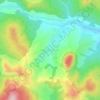
Name: Moigrad-Porolissum topographic map, elevation, terrain.
Location: Moigrad-Porolissum, Mirșid, Sălaj, 457252, Romania (47.17702 23.12387 47.21702 23.16387)
Average elevation: 366 m
Minimum elevation: 242 m
Maximum elevation: 575 m
Make a donation
Other topographic maps
Click on a map to view its topography, its elevation and its terrain.
Make a donation
Zalău
The city includes a total surface of 90.09 km2 (34.78 sq mi). This includes the one village it administers, Stâna (Felsőnyárló), situated south-east of Meseș, in the hydrographic basin of the Agrij River. Măgura Stânii is at an altitude of 716 m (2,349 ft).
Average elevation: 317 m
Make a donation
Make a donation
Zalău
The city includes a total surface of 90.09 km2 (34.78 sq mi). This includes the one village it administers, Stâna (Felsőnyárló), situated south-east of Meseș, in the hydrographic basin of the Agrij River. Măgura Stânii is at an altitude of 716 m (2,349 ft).
Average elevation: 346 m
Make a donation