
Thank you for supporting this site ❤️
Make a donation
Make a donation
Wheelock topographic map
Click on the map to display elevation.
Thank you for supporting this site ❤️
Make a donation
Make a donation
Wheelock
The highest point in town is Wheelock Mountain, with an elevation of 2,782 feet (848 m).
Thank you for supporting this site ❤️
Make a donation
Make a donation
About this map
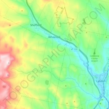
Name: Wheelock topographic map, elevation, terrain.
Location: Wheelock, Caledonia County, Vermont, 05851, United States (44.51037 -72.23734 44.62410 -72.05769)
Average elevation: 412 m
Minimum elevation: 206 m
Maximum elevation: 841 m
Thank you for supporting this site ❤️
Make a donation
Make a donation
Other topographic maps
Click on a map to view its topography, its elevation and its terrain.
Thank you for supporting this site ❤️
Make a donation
Make a donation
Thank you for supporting this site ❤️
Make a donation
Make a donation
East Saint Johnsbury
United States > Vermont > Caledonia County > Saint Johnsbury
Average elevation: 311 m
Thank you for supporting this site ❤️
Make a donation
Make a donation