
Make a donation
Teresa topographic map
Click on the map to display elevation.
Make a donation
About this map
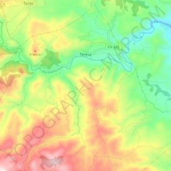
Name: Teresa topographic map, elevation, terrain.
Average elevation: 752 m
Minimum elevation: 524 m
Maximum elevation: 1,047 m
Make a donation
Other topographic maps
Click on a map to view its topography, its elevation and its terrain.
La Mata
Spain > Valencian Community > el Baix Segura / La Vega Baja > Torrevieja
Average elevation: 5 m
Make a donation
Make a donation
Raiguero de Bonanza
Spain > Valencian Community > el Baix Segura / La Vega Baja > Orihuela
Average elevation: 139 m
Coma Breco
Spain > Valencian Community > el Poble Nou de Benitatxell / Benitachell
Average elevation: 147 m
Make a donation
Make a donation
Balsa de riego goteo Pozo la Esperanza
Spain > Valencian Community > Nàquera / Náquera
Average elevation: 92 m
Make a donation
Castell de Benissili
Spain > Valencian Community > la Vall de Gallinera > Benissili
Average elevation: 629 m
Make a donation
Castell de Benissili
Spain > Valencian Community > la Vall de Gallinera > Benissili
Average elevation: 629 m
La Mata
Spain > Valencian Community > el Baix Segura / La Vega Baja > Torrevieja
Average elevation: 5 m
Make a donation
Cap de la Nau
Spain > Valencian Community > Xàbia / Jávea
Atop the headland, at an elevation of 120 metres (390 ft), stands the Cap de la Nau lighthouse, providing an important aid to navigation.
Average elevation: 32 m
Playa Flamenca I
Spain > Valencian Community > el Baix Segura / La Vega Baja del Segura > Orihuela > Urbanización La Zenia
Average elevation: 25 m
Make a donation
Platja del Cabanyal - Les Arenes
Spain > Valencian Community > Comarca de València > Valencia
Average elevation: 2 m
Make a donation
la Garrotxa
Spain > Valencian Community > Castelló / Castellón > Cervera del Maestre
Average elevation: 273 m
Cabo Roig
Spain > Valencian Community > el Baix Segura / La Vega Baja del Segura > Orihuela
Average elevation: 9 m
Make a donation
Dehesa de Campoamor
Spain > Valencian Community > el Baix Segura / La Vega Baja del Segura > Orihuela
Average elevation: 28 m
Make a donation
Make a donation
Urbanización Doña Pepa
Spain > Valencian Community > el Baix Segura / La Vega Baja del Segura > Rojales
Average elevation: 24 m
Make a donation
Torre de la Horadada
Spain > Valencian Community > el Baix Segura / La Vega Baja del Segura > Pilar de la Horadada
Average elevation: 5 m
Make a donation
Plaza Antigua Fábrica Fernando Diago
Spain > Valencian Community > Castelló / Castellón > Castelló de la Plana
Average elevation: 35 m
Make a donation
Vila-real
Spain > Valencian Community > Castelló / Castellón > Vila-real > Vila-real
Average elevation: 42 m
Villa Martín
Spain > Valencian Community > el Baix Segura / La Vega Baja del Segura > Orihuela > Villa Martín
Average elevation: 74 m
Bassa de Ferrara
Spain > Valencian Community > Castelló / Castellón > la Pobla Tornesa
Average elevation: 477 m
Make a donation
Make a donation