
Thank you for supporting this site ❤️
Make a donation
Make a donation
Schaerbeek topographic map
Click on the map to display elevation.
Thank you for supporting this site ❤️
Make a donation
Make a donation
About this map
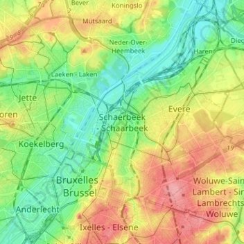
Name: Schaerbeek topographic map, elevation, terrain.
Location: Schaerbeek, Bruxelles-Capitale, 10303, Belgique (50.82760 4.33371 50.90760 4.41371)
Average elevation: 48 m
Minimum elevation: 10 m
Maximum elevation: 100 m
Thank you for supporting this site ❤️
Make a donation
Make a donation