
Thank you for supporting this site ❤️
Make a donation
Make a donation
Hutchinson topographic map
Click on the map to display elevation.
Thank you for supporting this site ❤️
Make a donation
Make a donation
About this map
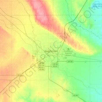
Name: Hutchinson topographic map, elevation, terrain.
Location: Hutchinson, Reno County, Kansas, 67504, United States (37.90084 -98.08977 38.22084 -97.76977)
Average elevation: 474 m
Minimum elevation: 437 m
Maximum elevation: 527 m
Thank you for supporting this site ❤️
Make a donation
Make a donation
Other topographic maps
Click on a map to view its topography, its elevation and its terrain.