
Thank you for supporting this site ❤️
Make a donation
Make a donation
Ness Lake topographic map
Click on the map to display elevation.
Thank you for supporting this site ❤️
Make a donation
Make a donation
About this map
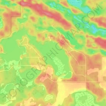
Name: Ness Lake topographic map, elevation, terrain.
Average elevation: 787 m
Minimum elevation: 742 m
Maximum elevation: 823 m
Thank you for supporting this site ❤️
Make a donation
Make a donation
Other topographic maps
Click on a map to view its topography, its elevation and its terrain.
Brûlé Lake
Canada > British Columbia > Regional District of Fraser-Fort George > Area A (Salmon River/Lakes)
Average elevation: 780 m