
Thank you for supporting this site ❤️
Make a donation
Make a donation
Hillentrup topographic map
Click on the map to display elevation.
Thank you for supporting this site ❤️
Make a donation
Make a donation
About this map
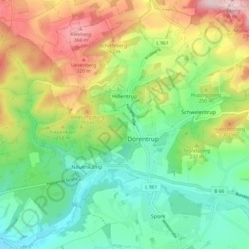
Name: Hillentrup topographic map, elevation, terrain.
Average elevation: 209 m
Minimum elevation: 104 m
Maximum elevation: 385 m
Thank you for supporting this site ❤️
Make a donation
Make a donation
Other topographic maps
Click on a map to view its topography, its elevation and its terrain.
Blomenstein
Deutschland > Nordrhein-Westfalen > Kreis Lippe > Dörentrup > Betzen
Average elevation: 192 m
Marksberg
Deutschland > Nordrhein-Westfalen > Kreis Lippe > Dörentrup > Humfeld
Average elevation: 232 m