
Parroquia Charallave topographic map
Interactive map
Click on the map to display elevation.
About this map
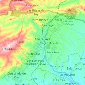
Name: Parroquia Charallave topographic map, elevation, terrain.
Average elevation: 377 m
Minimum elevation: 191 m
Maximum elevation: 971 m
Other topographic maps
Click on a map to view its topography, its elevation and its terrain.
Río Charallave
Venezuela > Estado Miranda > Municipio Cristóbal Rojas > Parroquia Charallave
Río Charallave, La Peña, Parroquia Charallave, Municipio Cristóbal Rojas, Estado Miranda, 1210, Venezuela
Average elevation: 347 m