
Piana topographic map
Interactive map
Click on the map to display elevation.
About this map
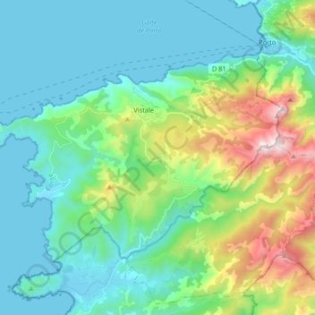
Name: Piana topographic map, elevation, terrain.
Average elevation: 298 m
Minimum elevation: -2 m
Maximum elevation: 1,311 m
Piana liegt in der Calanche auf einer Hochebene auf 438 m Höhe über dem Golf von Porto 78 km nördlich von Ajaccio und ist bekannt für seine steilwandigen Granitfelsen.