
Falcón topographic map
Interactive map
Click on the map to display elevation.
About this map
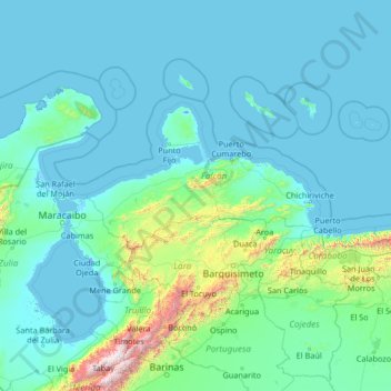
Name: Falcón topographic map, elevation, terrain.
Location: Falcón, Región Centroccidental, Venezuela (8.44000 -72.39333 13.56000 -67.27333)
Average elevation: 211 m
Minimum elevation: -5 m
Maximum elevation: 4,560 m
Other topographic maps
Click on a map to view its topography, its elevation and its terrain.
El Vizcaíno
Venezuela > Falcón > Municipio Píritu
El Vizcaíno, Parroquia Píritu, Municipio Píritu, Falcón, Venezuela
Average elevation: 17 m
Las Curvas
Venezuela > Falcón > Municipio Zamora > Las Curvas
Las Curvas, Parroquia Puerto Cumarebo, Municipio Zamora, Falcón, Región Centroccidental, Venezuela
Average elevation: 161 m
Río Santa Rita
Río Santa Rita, Coro, Municipio Miranda, Falcón, Venezuela
Average elevation: 64 m