
Thank you for supporting this site ❤️
Make a donation
Make a donation
Kelang Baharu topographic map
Click on the map to display elevation.
Thank you for supporting this site ❤️
Make a donation
Make a donation
About this map
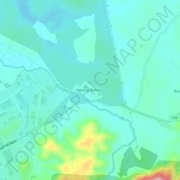
Name: Kelang Baharu topographic map, elevation, terrain.
Location: Kelang Baharu, Kulim, Kedah, 09090, Malaysia (5.41110 100.58957 5.45110 100.62957)
Average elevation: 46 m
Minimum elevation: 10 m
Maximum elevation: 212 m
Thank you for supporting this site ❤️
Make a donation
Make a donation
Other topographic maps
Click on a map to view its topography, its elevation and its terrain.