
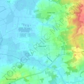
Sarzbüttel topographic map
Interactive map
Click on the map to display elevation.
About this map
Name: Sarzbüttel topographic map, elevation, terrain.
Average elevation: 14 m
Minimum elevation: -3 m
Maximum elevation: 62 m
Other topographic maps
Click on a map to view its topography, its elevation and its terrain.
Heide
Deutschland > Schleswig-Holstein > Dithmarschen
Heide, Dithmarschen, Schleswig-Holstein, 25746, Deutschland
Average elevation: 5 m
Norderwöhrden
Deutschland > Schleswig-Holstein > Dithmarschen
Norderwöhrden, Heider Umland, Dithmarschen, Schleswig-Holstein, Deutschland
Average elevation: 2 m