
Naddi topographic map
Click on the map to display elevation.
About this map
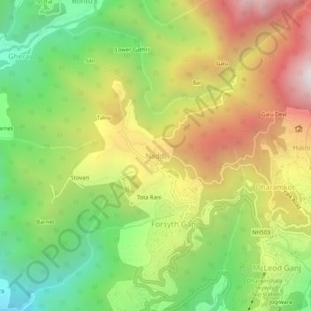
Name: Naddi topographic map, elevation, terrain.
Location: Naddi, Dharamshala, Kangra, Himachal Pradesh, 176216, India (32.22959 76.28781 32.26959 76.32781)
Average elevation: 1,713 m
Minimum elevation: 1,052 m
Maximum elevation: 2,507 m
Other topographic maps
Click on a map to view its topography, its elevation and its terrain.