
Fondi topographic map
Interactive map
Click on the map to display elevation.
About this map
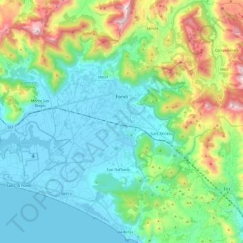
Name: Fondi topographic map, elevation, terrain.
Location: Fondi, Latina, Lazio, 04022, Italy (41.27365 13.28113 41.40465 13.51276)
Average elevation: 261 m
Minimum elevation: -3 m
Maximum elevation: 1,044 m
Other topographic maps
Click on a map to view its topography, its elevation and its terrain.
Cisterna di Latina
Italy > Lazio > Latina > Cisterna di Latina
Cisterna di Latina, Latina, Lazio, 04012, Italy
Average elevation: 100 m