
Fresno topographic map
Click on the map to display elevation.
About this map
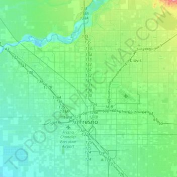
Name: Fresno topographic map, elevation, terrain.
Location: Fresno, Fresno County, California, United States (36.66216 -119.93440 36.90891 -119.65054)
Average elevation: 99 m
Minimum elevation: 71 m
Maximum elevation: 216 m
Other topographic maps
Click on a map to view its topography, its elevation and its terrain.
Shaver Lake
United States > California > Fresno County > Shaver Lake
Shaver Lake (formerly, Musick Creek and Musick Creek Heights) is a census-designated place (CDP) in Fresno County, California, United States. The population was 634 at the 2010 census, down from 705 at the 2000 census. Shaver Lake is on the southwest end of the lake of the same name, 10 miles (16 km) east of…
Average elevation: 1,437 m
Yokuts Valley
United States > California > Fresno County
As of the 2010 census, the CDP had a total population of 3,162, up from 2,691 at the 2000 census. For statistical purposes, the United States Census Bureau defined Squaw Valley as a census-designated place (CDP). Yokuts Valley is located 9 miles (14 km) north-northeast of Orange Cove and 30 miles (48 km) east…
Average elevation: 550 m
Friant
United States > California > Fresno County > Friant
Friant (formerly, Converse Ferry, Jones Ferry, Hamptonville, and Pollasky) is a census-designated place (CDP) in Fresno County, California, United States. The population was 549 at the 2010 census, down from 778 at the 2000 census. Friant is located 11.5 miles (19 km) north of Clovis, at an elevation of 344…
Average elevation: 135 m
Reedley
United States > California > Fresno County
Reedley is a city in Fresno County, California, United States. It is located in the San Joaquin Valley, 22 miles (35 km) east-southeast of Fresno, at an elevation of 348 feet (106 m). The population at the 2010 census was 24,194. Its chief economic source is agriculture, particularly fruit and vegetable…
Average elevation: 106 m
Piedra
United States > California > Fresno County
Piedra (Spanish for "Stone") is an unincorporated community in Fresno County, California. It is located on the south bank of the Kings River 23 miles (37 km) east of Fresno, at an elevation of 538 feet (164 m).
Average elevation: 263 m
Charlotte Lake
United States > California > Fresno County
Charlotte Lake (also known as Charlotta Lake, or Rhoda Lake) is a lake in the Sierra Nevada, located in Kings Canyon National Park, eastern Fresno County, California. The lake is located on the John Muir Trail, at an elevation of 10,544 feet (3,214 m).
Average elevation: 3,332 m
Shaver Lake
United States > California > Fresno County > Shaver Lake
Shaver Lake (formerly Musick Creek and Musick Creek Heights) is a census-designated place (CDP) in Fresno County, California, United States. The population was 580 at the 2020 census, down from 634 at the 2010 census. Shaver Lake is on the southwest end of the lake of the same name, 10 miles (16 km) east of…
Average elevation: 1,437 m