
Thank you for supporting this site ❤️
Make a donation
Make a donation
Pawlowsk topographic map
Click on the map to display elevation.
Thank you for supporting this site ❤️
Make a donation
Make a donation
About this map
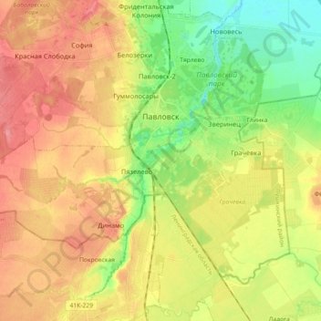
Name: Pawlowsk topographic map, elevation, terrain.
Average elevation: 50 m
Minimum elevation: 14 m
Maximum elevation: 82 m
Thank you for supporting this site ❤️
Make a donation
Make a donation
Other topographic maps
Click on a map to view its topography, its elevation and its terrain.
Sankt Petersburg
Russland > Sankt Petersburg > Sankt Petersburg
Die ursprünglich in einem Sumpfgebiet gebaute Stadt liegt an der Mündung der Newa in den Finnischen Meerbusen. Das Stadtgebiet umfasst etwa 1.431 km² einschließlich der administrativ seit 1999 zu Sankt Petersburg gehörenden Vororte wie Peterhof und Puschkin, davon etwa 10 Prozent Wasser. Die Stadt besteht…
Average elevation: 14 m