
Thank you for supporting this site ❤️
Make a donation
Make a donation
Gelmersee topographic map
Click on the map to display elevation.
Thank you for supporting this site ❤️
Make a donation
Make a donation
Gelmersee
蓋爾默湖(Gelmersee),是瑞士的水庫,位於該國中部,處於伯爾尼高地,長1.3公里、寬1.1公里,面積0.6平方公里,海拔高度1,850米,最大水深48米,水體容量1,300萬立方米。
Thank you for supporting this site ❤️
Make a donation
Make a donation
About this map
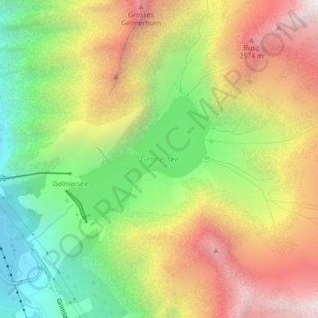
Name: Gelmersee topographic map, elevation, terrain.
Average elevation: 2,068 m
Minimum elevation: 1,404 m
Maximum elevation: 2,815 m
Thank you for supporting this site ❤️
Make a donation
Make a donation