
Thank you for supporting this site ❤️
Make a donation
Make a donation
Rajegwesi topographic map
Click on the map to display elevation.
Thank you for supporting this site ❤️
Make a donation
Make a donation
About this map
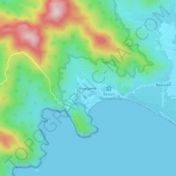
Name: Rajegwesi topographic map, elevation, terrain.
Location: Rajegwesi, Banyuwangi, East Java, Java, Indonesia (-8.57554 113.91498 -8.53554 113.95498)
Average elevation: 89 m
Minimum elevation: -2 m
Maximum elevation: 396 m
Thank you for supporting this site ❤️
Make a donation
Make a donation
Other topographic maps
Click on a map to view its topography, its elevation and its terrain.