Make a donation
Dwarda topographic map
Click on the map to display elevation.
Make a donation
About this map
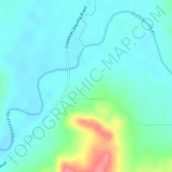
Name: Dwarda topographic map, elevation, terrain.
Location: Dwarda, Shire Of Wandering, Western Australia, Australia (-32.77684 116.67370 -32.75684 116.69370)
Average elevation: 245 m
Minimum elevation: 228 m
Maximum elevation: 310 m
Make a donation
Other topographic maps
Click on a map to view its topography, its elevation and its terrain.
Make a donation
Make a donation
Make a donation
Make a donation
Make a donation
Clackline
Clackline Bridge is a historic road bridge in Clackline that carried the Great Eastern Highway until 2008. It is the only bridge in Western Australia to have spanned both a waterway and railway, the Clackline Brook and the former Eastern Railway alignment. The mainly timber bridge has a unique curved and…
Average elevation: 286 m
Make a donation
Make a donation
Make a donation
Make a donation
Make a donation
Make a donation
Make a donation
Make a donation
Make a donation
Make a donation
Make a donation
Make a donation
Make a donation
Make a donation
Make a donation
Make a donation
Make a donation
Make a donation
Make a donation
Henley Brook
Henley Brook is situated on the flood plains of the Swan River, with regularly occurring seasonal floods. Two ephemeral streams from the river - Henley Brook and St. Leonard's Creek - traverse the suburb. Henley Brook is in the north-east near Brockman Street, while St Leonards Creek traverses the centre of…
Average elevation: 28 m
Make a donation
