
Thank you for supporting this site ❤️
Make a donation
Make a donation
Vieux Pellafol topographic map
Click on the map to display elevation.
Thank you for supporting this site ❤️
Make a donation
Make a donation
About this map
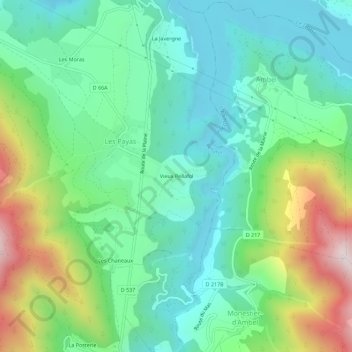
Name: Vieux Pellafol topographic map, elevation, terrain.
Average elevation: 980 m
Minimum elevation: 727 m
Maximum elevation: 1,586 m
Thank you for supporting this site ❤️
Make a donation
Make a donation
Other topographic maps
Click on a map to view its topography, its elevation and its terrain.
38970
France > Auvergne-Rhône-Alpes > Isère > Pellafol > Les Payas > La Javergne
Average elevation: 1,300 m