
Thank you for supporting this site ❤️
Make a donation
Make a donation
Les Prud'hommes topographic map
Click on the map to display elevation.
Thank you for supporting this site ❤️
Make a donation
Make a donation
About this map
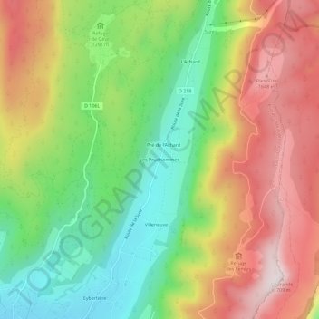
Name: Les Prud'hommes topographic map, elevation, terrain.
Average elevation: 1,361 m
Minimum elevation: 1,058 m
Maximum elevation: 1,709 m
Thank you for supporting this site ❤️
Make a donation
Make a donation
Other topographic maps
Click on a map to view its topography, its elevation and its terrain.
Falaises du Vercors – Rochers du Cumacle
France > Auvergne-Rhône-Alpes > Isère > Autrans-Méaudre en Vercors > Autrans
Average elevation: 1,136 m