
Thank you for supporting this site ❤️
Make a donation
Make a donation
Porto-Novo topographic map
Click on the map to display elevation.
Thank you for supporting this site ❤️
Make a donation
Make a donation
Porto-Novo
Porto-Novo is located in the south of Benin, 13 kilometers from the Atlantic Ocean, separated by a lagoon. Its altitude is approximately 38 meters and it covers an area of 52 km².
Thank you for supporting this site ❤️
Make a donation
Make a donation
About this map
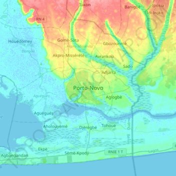
Name: Porto-Novo topographic map, elevation, terrain.
Location: Porto-Novo, Porto Novo, Ouémé Department, Benin (6.33907 2.46534 6.65907 2.78534)
Average elevation: 15 m
Minimum elevation: -4 m
Maximum elevation: 71 m
Thank you for supporting this site ❤️
Make a donation
Make a donation