
Thank you for supporting this site ❤️
Make a donation
Make a donation
Sanpetru topographic map
Click on the map to display elevation.
Thank you for supporting this site ❤️
Make a donation
Make a donation
About this map
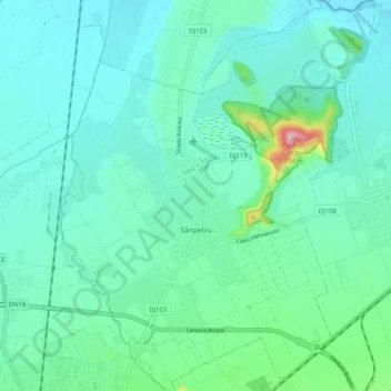
Name: Sanpetru topographic map, elevation, terrain.
Location: Sanpetru, Zona Metropolitană Brașov, Brașov, Romania (45.67761 25.59705 45.74784 25.67844)
Average elevation: 528 m
Minimum elevation: 495 m
Maximum elevation: 691 m
Thank you for supporting this site ❤️
Make a donation
Make a donation
Other topographic maps
Click on a map to view its topography, its elevation and its terrain.
Postăvaru
The Postăvarul massif (Transylvanian German Schuler and Schulerberg, or Hungarian Keresztényhavas) is a massif in Romania; it is part of the Romanian Carpathians, which in turn are part of the Carpathian Mountains range. The altitude of the highest peak, also named Postăvarul is 1799 metres.
Average elevation: 1,362 m
Thank you for supporting this site ❤️
Make a donation
Make a donation
Thank you for supporting this site ❤️
Make a donation
Make a donation
Thank you for supporting this site ❤️
Make a donation
Make a donation
Thank you for supporting this site ❤️
Make a donation
Make a donation
Thank you for supporting this site ❤️
Make a donation
Make a donation
Thank you for supporting this site ❤️
Make a donation
Make a donation
Thank you for supporting this site ❤️
Make a donation
Make a donation