
Thank you for supporting this site ❤️
Make a donation
Make a donation
Bad Vöslau topographic map
Click on the map to display elevation.
Thank you for supporting this site ❤️
Make a donation
Make a donation
About this map
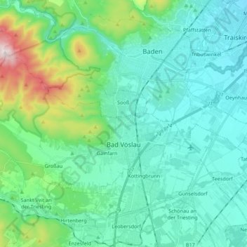
Name: Bad Vöslau topographic map, elevation, terrain.
Location: Bad Vöslau, Bezirk Baden, Lower Austria, Austria (47.94335 16.08584 48.00650 16.25249)
Average elevation: 313 m
Minimum elevation: 194 m
Maximum elevation: 831 m
Thank you for supporting this site ❤️
Make a donation
Make a donation
Other topographic maps
Click on a map to view its topography, its elevation and its terrain.
Matterhorn
Austria > Lower Austria > Bezirk Baden > Altenmarkt an der Triesting
Average elevation: 526 m