
Getelo topographic map
Interactive map
Click on the map to display elevation.
About this map
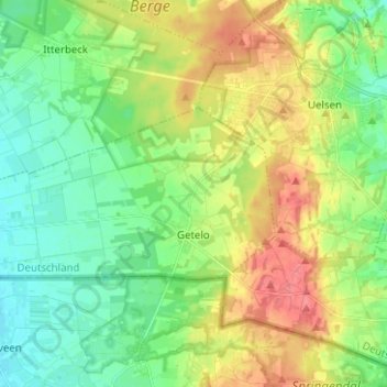
Name: Getelo topographic map, elevation, terrain.
Average elevation: 48 m
Minimum elevation: 22 m
Maximum elevation: 89 m
Other topographic maps
Click on a map to view its topography, its elevation and its terrain.
Getelomoor
Duitsland > Nedersaksen > Landkreis Grafschaft Bentheim > Getelo > Getelomoor
Getelomoor, Getelo, Samtgemeinde Uelsen, Landkreis Grafschaft Bentheim, Nedersaksen, 49847, Duitsland
Average elevation: 23 m