
Sesto Fiorentino topographic map
Interactive map
Click on the map to display elevation.
About this map
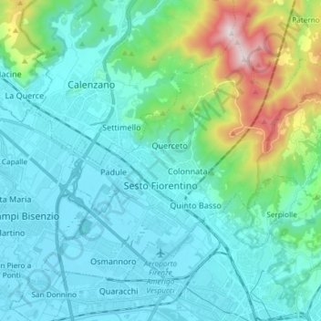
Name: Sesto Fiorentino topographic map, elevation, terrain.
Average elevation: 187 m
Minimum elevation: 30 m
Maximum elevation: 925 m
Other topographic maps
Click on a map to view its topography, its elevation and its terrain.
Fiesole
Italy > Tuscany > Metropolitan City of Florence
Fiesole, Metropolitan City of Florence, Tuscany, Italy
Average elevation: 265 m
Morrocco
Italy > Tuscany > Metropolitan City of Florence > Sambuca
Morrocco, Sambuca, Barberino Tavarnelle, Metropolitan City of Florence, Tuscany, 50028, Italy
Average elevation: 288 m
Lamole
Italy > Tuscany > Metropolitan City of Florence > Greve in Chianti > Lamole
Lamole, Greve in Chianti, Metropolitan City of Florence, Tuscany, 50022, Italy
Average elevation: 575 m
Castello di Lamole
Italy > Tuscany > Metropolitan City of Florence > Greve in Chianti > Castello di Lamole
Castello di Lamole, Greve in Chianti, Metropolitan City of Florence, Tuscany, 50022, Italy
Average elevation: 588 m
Empoli
Italy > Tuscany > Metropolitan City of Florence > Empoli
Empoli, Metropolitan City of Florence, Tuscany, 50053, Italy
Average elevation: 58 m
Sant'Appiano
Italy > Tuscany > Metropolitan City of Florence > Sant'Appiano
Sant'Appiano, Barberino Tavarnelle, Metropolitan City of Florence, Tuscany, 50021, Italy
Average elevation: 191 m
Borro Bologna
Italy > Tuscany > Metropolitan City of Florence > Reggello > San Giovenale
Borro Bologna, San Giovenale, Reggello, Castelfranco Piandiscò, Metropolitan City of Florence, Tuscany, 52026, Italy
Average elevation: 349 m
Scarperia e San Piero
Italy > Tuscany > Metropolitan City of Florence
Scarperia e San Piero, Metropolitan City of Florence, Tuscany, Italy
Average elevation: 430 m
Galliano
Italy > Tuscany > Metropolitan City of Florence > Barberino di Mugello
Galliano, Barberino di Mugello, Metropolitan City of Florence, Tuscany, Italy
Average elevation: 339 m