
Make a donation
Jerusalem topographic map
Click on the map to display elevation.
Make a donation
Jerusalem
Jerusalem occupies a rugged hilltop setting on a rocky spur within the Judaean Mountains, where the urban landscape rises around about 2,575 feet (785 m) above sea level and is shaped by a compact pattern of limestone ridges, saddles, slopes, and deeply incised dry valleys. The Old City and surrounding districts stand above the Kidron, Hinnom, and Tyropoeon valleys, while Mount Scopus and the Mount of Olives form prominent high ground to the north and east, reinforcing the city’s strongly dissected relief. Westward, the terrain continues into the hilly Judean uplands, whereas eastward it descends abruptly toward the arid Judean Desert and the Dead Sea basin, giving Jerusalem a marked physical contrast between elevated Mediterranean highland terrain and steep desert-facing escarpments.
Make a donation
About this map
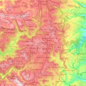
Name: Jerusalem topographic map, elevation, terrain.
Location: Jerusalem, Jerusalem Subdistrict, Jerusalem District, Israel (31.71704 35.15238 31.85973 35.26122)
Average elevation: 673 m
Minimum elevation: 303 m
Maximum elevation: 921 m
Make a donation