
Make a donation
Jerusalem topographic map
Click on the map to display elevation.
Make a donation
Jerusalem
Jerusalem is situated on the southern spur of a plateau in the Judaean Mountains, which include the Mount of Olives (East) and Mount Scopus (North East). The elevation of the Old City is approximately 760 m (2,490 ft). The whole of Jerusalem is surrounded by valleys and dry riverbeds (wadis). The Kidron, Hinnom, and Tyropoeon Valleys intersect in an area just south of the Old City of Jerusalem. The Kidron Valley runs to the east of the Old City and separates the Mount of Olives from the city proper. Along the southern side of old Jerusalem is the Valley of Hinnom, a steep ravine associated in biblical eschatology with the concept of Gehenna or Hell.
Make a donation
About this map
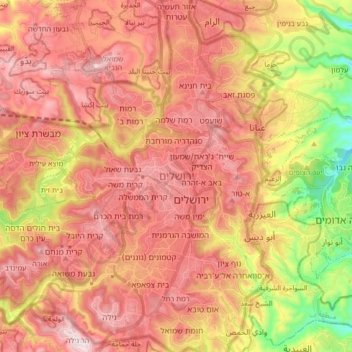
Name: Jerusalem topographic map, elevation, terrain.
Location: Jerusalem, Jerusalem Subdistrict, Jerusalem District, Israel (31.71704 35.15238 31.85973 35.26122)
Average elevation: 673 m
Minimum elevation: 303 m
Maximum elevation: 921 m
Make a donation