
Jelgava topographic map
Interactive map
Click on the map to display elevation.
About this map
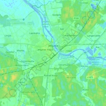
Name: Jelgava topographic map, elevation, terrain.
Location: Jelgava, Zemgale, Letland (56.59687 23.62350 56.69184 23.79957)
Average elevation: 5 m
Minimum elevation: -4 m
Maximum elevation: 17 m
Other topographic maps
Click on a map to view its topography, its elevation and its terrain.
Tīnūžu pagasts
Letland > Zemgale > Ogres novads
Tīnūžu pagasts, Ogres novads, Zemgale, LV-5052, Letland
Average elevation: 34 m