
Thank you for supporting this site ❤️
Make a donation
Make a donation
Stubenberg topographic map
Click on the map to display elevation.
Thank you for supporting this site ❤️
Make a donation
Make a donation
About this map
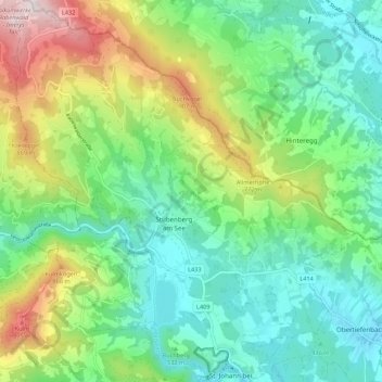
Name: Stubenberg topographic map, elevation, terrain.
Location: Stubenberg, Bezirk Hartberg-Fürstenfeld, Styria, 8223, Austria (47.21385 15.75657 47.28736 15.85294)
Average elevation: 588 m
Minimum elevation: 352 m
Maximum elevation: 1,126 m
Thank you for supporting this site ❤️
Make a donation
Make a donation
Other topographic maps
Click on a map to view its topography, its elevation and its terrain.
Stubenberg am See
Austria > Styria > Bezirk Hartberg-Fürstenfeld > Stubenberg
Average elevation: 539 m