
Fluchthorn topographic map
Interactive map
Click on the map to display elevation.
About this map
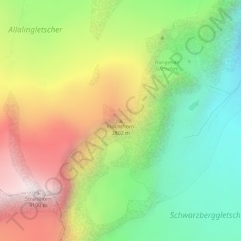
Name: Fluchthorn topographic map, elevation, terrain.
Location: Fluchthorn, Saas-Almagell, Visp, Wallis, 3905, Schweiz (46.02116 7.91543 46.02126 7.91553)
Average elevation: 3,355 m
Minimum elevation: 2,733 m
Maximum elevation: 4,182 m
Other topographic maps
Click on a map to view its topography, its elevation and its terrain.
Feegletscher
Schweiz > Wallis > Saas-Almagell
Feegletscher, Zustieg Hohlaubgrat, Saas-Almagell, Visp, Wallis, 3905, Schweiz
Average elevation: 3,247 m
Allalingletscher
Schweiz > Wallis > Saas-Almagell
Allalingletscher, Zustieg Hohlaubgrat, Saas-Almagell, Visp, Wallis, 3905, Schweiz
Average elevation: 3,388 m
Hohlaubgletscher
Schweiz > Wallis > Saas-Almagell
Hohlaubgletscher, Zustieg Hohlaubgrat, Saas-Almagell, Visp, Wallis, 3905, Schweiz
Average elevation: 3,247 m