
Ehlingen topographic map
Interactive map
Click on the map to display elevation.
About this map
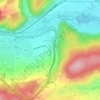
Name: Ehlingen topographic map, elevation, terrain.
Average elevation: 136 m
Minimum elevation: 63 m
Maximum elevation: 246 m
Other topographic maps
Click on a map to view its topography, its elevation and its terrain.
Neuenahr
Duitsland > Rijnland-Palts > Landkreis Ahrweiler > Bad Neuenahr-Ahrweiler
Neuenahr, Bad Neuenahr-Ahrweiler, Landkreis Ahrweiler, Rijnland-Palts, Duitsland
Average elevation: 242 m