
Thank you for supporting this site ❤️
Make a donation
Make a donation
Parroquia Yocoima topographic map
Click on the map to display elevation.
Thank you for supporting this site ❤️
Make a donation
Make a donation
About this map
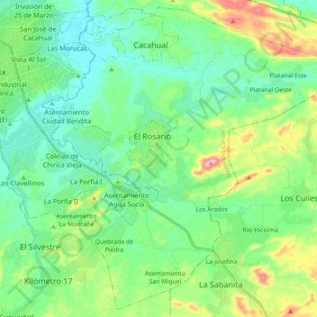
Name: Parroquia Yocoima topographic map, elevation, terrain.
Location: Parroquia Yocoima, Municipio Caroní, Estado Bolívar, Venezuela (8.21693 -62.61682 8.38269 -62.44112)
Average elevation: 94 m
Minimum elevation: 14 m
Maximum elevation: 328 m
Thank you for supporting this site ❤️
Make a donation
Make a donation
Other topographic maps
Click on a map to view its topography, its elevation and its terrain.