
Roraima topographic map
Click on the map to display elevation.
Roraima
Mount Roraima, located in Pacaraima Mountains, is the highest point in the state and one of the highest in the country, with 2,875 m (9,400 feet). The relief in the state is quite varied. Near the borders of Venezuela and Guyana are the mountains of Parima and Pacaraima, where Mount Roraima is located, with an altitude of 2,875 m (9,400 feet). As it is in the far north of Brazil, its points in the far north are the Uailan River and Mount Caburaí.
About this map
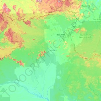
Name: Roraima topographic map, elevation, terrain.
Location: Roraima, North Region, Brazil (-1.59386 -64.82721 5.26958 -58.88600)
Average elevation: 260 m
Minimum elevation: 10 m
Maximum elevation: 2,784 m
Other topographic maps
Click on a map to view its topography, its elevation and its terrain.
Domingos Martins
Brazil > Espírito Santo > Domingos Martins > Domingos Martins
Average elevation: 623 m