
Taylor's Hill topographic map
Interactive map
Click on the map to display elevation.
About this map
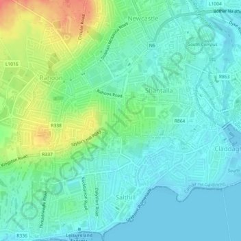
Name: Taylor's Hill topographic map, elevation, terrain.
Location: Taylor's Hill, Galway City, County Galway, Connacht, Ireland (53.26700 -9.08830 53.27421 -9.06266)
Average elevation: 16 m
Minimum elevation: -1 m
Maximum elevation: 57 m
Other topographic maps
Click on a map to view its topography, its elevation and its terrain.
Galway City
Ireland > County Galway > Galway City
Galway City, County Galway, Connacht, Ireland
Average elevation: 15 m