
Thank you for supporting this site ❤️
Make a donation
Make a donation
Rabat topographic map
Click on the map to display elevation.
Thank you for supporting this site ❤️
Make a donation
Make a donation
About this map
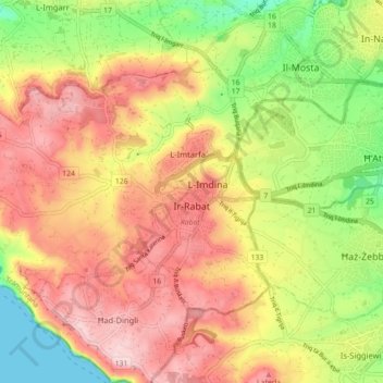
Name: Rabat topographic map, elevation, terrain.
Location: Rabat, Western Region, Malta (35.86148 14.32814 35.90767 14.41699)
Average elevation: 135 m
Minimum elevation: 0 m
Maximum elevation: 252 m
Thank you for supporting this site ❤️
Make a donation
Make a donation
Other topographic maps
Click on a map to view its topography, its elevation and its terrain.
Thank you for supporting this site ❤️
Make a donation
Make a donation
Baħrija
Baħrija is one of the highest places in Malta, therefore the weather here is cooler than at lower elevations (it is also exposed to the cold northern winds coming over the sea). Most of the north of Malta is visible from this village, but the south west of Gozo (including Xlendi) is also visible, and on clear…
Average elevation: 116 m
Thank you for supporting this site ❤️
Make a donation
Make a donation
Thank you for supporting this site ❤️
Make a donation
Make a donation