
Make a donation
Lake Carmel topographic map
Click on the map to display elevation.
Make a donation
About this map
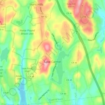
Name: Lake Carmel topographic map, elevation, terrain.
Average elevation: 221 m
Minimum elevation: 149 m
Maximum elevation: 334 m
Make a donation
Other topographic maps
Click on a map to view its topography, its elevation and its terrain.
Lake Peekskill
United States > New York > Putnam County > Town of Putnam Valley
Average elevation: 103 m
Oscawana Corners
United States > New York > Putnam County > Town of Putnam Valley
Average elevation: 158 m
Make a donation
Make a donation
Barnum Corners
United States > New York > Putnam County > Town of Patterson > Putnam Lake
Average elevation: 174 m
Lake Tonetta
United States > New York > Putnam County > Brewster > Brewster Hill
Average elevation: 155 m
Make a donation
Crofts Corners
United States > New York > Putnam County > Town of Putnam Valley
Average elevation: 141 m
Make a donation
Kent Cliffs Unit
United States > New York > Putnam County > Town of Putnam Valley > Richardsville
Average elevation: 270 m
Make a donation
Tompkins Corners
United States > New York > Putnam County > Town of Putnam Valley
Average elevation: 208 m
Stillwater Pond
United States > New York > Putnam County > Town of Putnam Valley
Average elevation: 288 m
Make a donation