
Thank you for supporting this site ❤️
Make a donation
Make a donation
Vauréal topographic map
Click on the map to display elevation.
Thank you for supporting this site ❤️
Make a donation
Make a donation
About this map
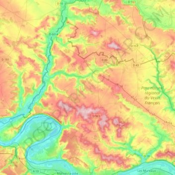
Name: Vauréal topographic map, elevation, terrain.
Location: Vauréal, Val-d'Oise, Ile-de-France, Metropolitan France, France (49.01387 1.60776 49.24143 2.04077)
Average elevation: 102 m
Minimum elevation: 12 m
Maximum elevation: 211 m
Thank you for supporting this site ❤️
Make a donation
Make a donation
Other topographic maps
Click on a map to view its topography, its elevation and its terrain.