
Thank you for supporting this site ❤️
Make a donation
Make a donation
Maple Ridge topographic map
Click on the map to display elevation.
Thank you for supporting this site ❤️
Make a donation
Make a donation
About this map
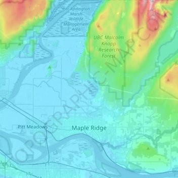
Name: Maple Ridge topographic map, elevation, terrain.
Average elevation: 185 m
Minimum elevation: -3 m
Maximum elevation: 1,568 m
Thank you for supporting this site ❤️
Make a donation
Make a donation
Other topographic maps
Click on a map to view its topography, its elevation and its terrain.
Navvy Jack Point Park
Canada > British Columbia > Metro Vancouver Regional District > West Vancouver
Average elevation: 23 m