
Make a donation
San Juan topographic map
Click on the map to display elevation.
Make a donation
About this map
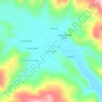
Name: San Juan topographic map, elevation, terrain.
Location: San Juan, Antauta, Province of Melgar, Puno, Peru (-14.54599 -70.41800 -14.50599 -70.37800)
Average elevation: 4,086 m
Minimum elevation: 3,978 m
Maximum elevation: 4,340 m
Make a donation
Other topographic maps
Click on a map to view its topography, its elevation and its terrain.
Lake Titicaca
Lake Titicaca has a surface elevation of 3,812 m (12,507 ft). The "highest navigable lake" claim is generally considered to refer to commercial craft. Numerous smaller bodies of water around the world are at higher elevations. For many years, the largest vessel afloat on the lake was the 2,200-ton (2,425 U.S.…
Average elevation: 3,870 m
Lake Titicaca (Peruvian sector)
Lake Titicaca has a surface elevation of 3,812 m (12,507 ft). The "highest lake" claim is generally considered to refer to commercial craft. Numerous smaller lakes around the world are at higher elevations. For many years, the largest vessel afloat on the lake was the 2,200-ton (2,425 U.S. tons), 79 m (259 ft)…
Average elevation: 4,012 m
Make a donation
Make a donation
Make a donation
Make a donation