
Thank you for supporting this site ❤️
Make a donation
Make a donation
Barton topographic map
Click on the map to display elevation.
Thank you for supporting this site ❤️
Make a donation
Make a donation
About this map
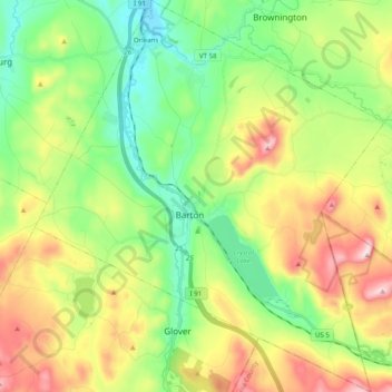
Name: Barton topographic map, elevation, terrain.
Location: Barton, Orleans County, Vermont, United States (44.68508 -72.25886 44.82542 -72.08241)
Average elevation: 398 m
Minimum elevation: 211 m
Maximum elevation: 714 m
Thank you for supporting this site ❤️
Make a donation
Make a donation
Other topographic maps
Click on a map to view its topography, its elevation and its terrain.
Thank you for supporting this site ❤️
Make a donation
Make a donation
Thank you for supporting this site ❤️
Make a donation
Make a donation